That’s why rapid intensification remains such a difficult thing to forecast. But scientists are using both decades-old data and new measurements to fix that. Last month, Wang published a paper in the journal Nature Communications analyzing the frequency of rapidly intensifying cyclones (“hurricane” is another word for cyclone) in the open ocean and within 250 miles of a coastline over the past four decades.
Courtesy of Yi Li
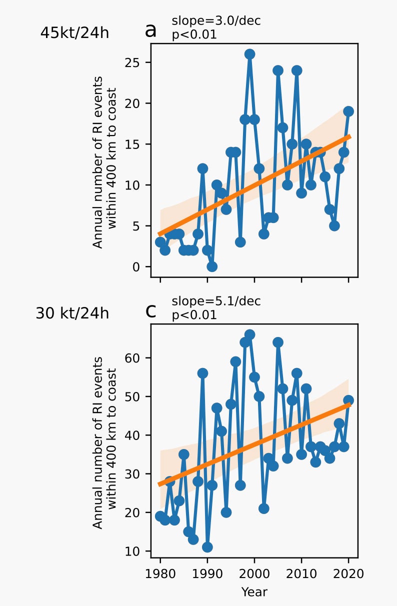
While Wang found no significant trend in the open ocean, the amount of rapid intensification exploded near coasts. (The graphs above show the number of rapid intensification events between the years 1980 and 2020. The bottom graph shows events where wind speed increased at least 30 knots in 24 hours, and the top shows even more extreme intensification of 45 knots.)
Idalia was a prime example of this, rapidly intensifying as it neared the Florida coast. “Four decades ago, we had five rapid intensification events in the coastal offshore region annually. But now we have 15, so the number has tripled,” says Wang. “We think vertical wind shear weakening and humidity increases may be two important reasons why we are seeing this very significant trend in rapid intensification events.”
Climate change, too, has been providing ever more heat energy for hurricanes to feed on: Earlier this summer, Florida logged water temperatures of 101 degrees Fahrenheit. Indeed, Wang’s analysis found that the rise in offshore rapid intensification could be due to both natural variability in the climate and human-caused climate change. While scientists will need to do specific studies to see how much climate change contributed to Idalia’s rapid intensification near the coast, it was a “scenario that we may see more in the future,” Wang says.
Similarly, climate scientist Karthik Balaguru, of the Pacific Northwest National Laboratory, has found that the Atlantic coast is becoming a breeding ground for rapidly intensifying hurricanes. Once again, the problem is expected to worsen with climate change. “We have identified warming of the sea, reducing wind shear, and also the atmosphere is becoming more and more moist,” says Balaguru. “All of these factors are becoming more and more favorable, making the environment in general more conducive for intensification.”
The wind shear factor is particularly interesting because it begins on the other side of the country. Climate models predict that the eastern Pacific Ocean is going to heat significantly, with maximum warming just north of the equator. “It basically sets off waves in the atmosphere,” Balaguru says. “These waves, in turn, change the circulation in the upper troposphere above North America. And one of the consequences of these circulation changes is that the wind shear will likely reduce, especially near coastal regions.” On the Atlantic coast, this reduced wind shear would favor the rapid intensification of hurricanes nearing landfall.
It’s yet another illustration of the confounding complexity of rapid intensification. But with more data, scientists can better understand the phenomenon and improve their models, giving coastal populations better warning of the monsters hurtling toward shore.